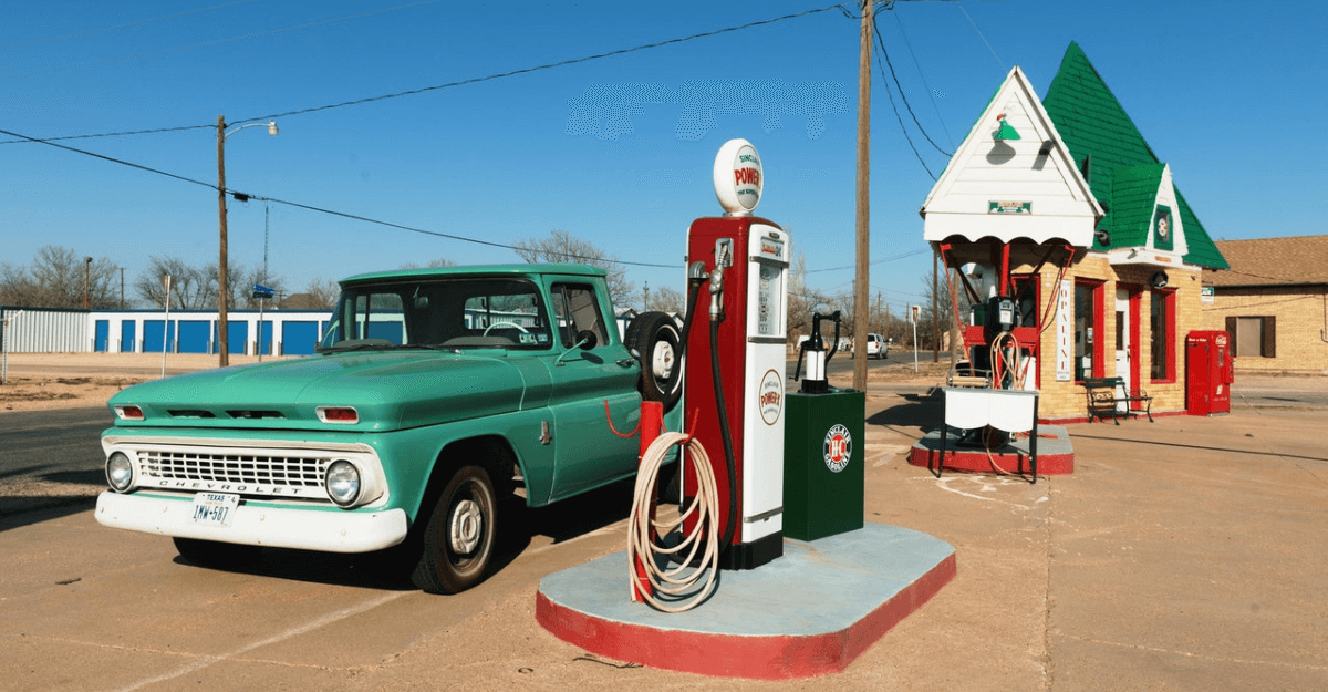
The Energy and Petroleum Regulatory Authority (EPRA) sets and enforces the environmental, health, safety, and quality standards in Kenya’s energy sector. To help EPRA in their mandate, petrol retail stations were mapped with ArcGIS Survey123 in 2020.
Challenge
EPRA’s mandate was extended under the energy and petroleum acts of 2019, but its manpower and financial resources remain constrained. Enforcement and compliance are further hampered by political interference and long judicial processes.
Meanwhile, petrol pumps are fast increasing in rural areas to serve boda boda operators who ferry passengers on motorbikes at rates that people can afford. Most of these pumps are constructed without a permit and operated without a business license from EPRA.
In urban areas, a different problem occurs. Petrol retail stations are classified in tier 1, 2, and 3 stations according to their land size, tier 1 being the smallest. As per their tier license they can provide certain facilities such as eateries or an office block. There are numerous cases where station owners offer facilities beyond their tier classification.
Safety is another key concern. Stations are often constructed very near to each other with disastrous consequences in case of fire. Moreover, many stations border residential areas and places of public assembly with no regard for safe distances.
To top it all up, EPRA must monitor and enforce compliance in collaboration with county governments and national government agencies that handle environment, health, and fire safety. At times it is not clear who does what and coordinating inspections is a real challenge.
Clearly EPRA faces a myriad of challenges in regulating the energy sector in a way that promotes and safeguards investment and protects health, safety, and the environment. What solutions can be found to address all these issues and concerns?
Solution
To do more with less, EPRA went looking for a technology solution that could improve the quality of their records and streamline field operations. With funding from the World Bank, they were able to acquire an ArcGIS solution under KEPTAP (Kenya Petroleum Technical Assistance Project).
The solution of an ArcGIS Enterprise deployment with ArcGIS Data Store, ArcGIS Server, and ArcGIS Enterprise Portal as the major software components. Since security is a key concern for EPRA, they implemented ArcGIS Enterprise since it runs safely behind a firewall. The functions and features of ArcGIS Enterprise Portal however are like ArcGIS Online.
To give EPRA a head start mapping of petrol retail stations and an initial compliance assessment was carried out by Esri Eastern in joint venture with AESA East Africa. Spatiality provided technical leadership and project management services and Kent Africa provided subject matter expertise. The project started in March 2020 and was completed in December 2020.
The purpose of the field data collection was to map the location of most if not all petrol retail stations across Kenya. In addition, all the data needed to assess compliance with the requirements of Kenya Standard 2504:2014 had to be collected. KS2504:2014 categorizes petrol retail stations as Tier 1, 2, 3 and 4 and specifies their requirements. A summary is provided in the table below:
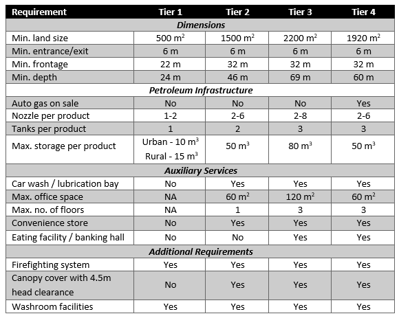
Tier 4 is reserved for stations that sell Auto gas. These are very few in Kenya and most petrol retail stations are classified as tier 1, 2, and 3. Land size is a limiting factor, particularly in urban areas, and a major cause of non-compliance. Particularly in Nairobi it is very common to find an eatery or a multi-store office block on land smaller than 2,200 m2.
Due to COVID-19 restrictions field data collection did not start until mid-July. Yet, to finish the project by the end of the year field work had to be completed by October. At the start it was estimated that 3,000 data points had to be collected, but in the end this figure rose to 5,000. Clearly the field enumerators had a momentous task at hand.
ArcGIS Survey123 to the Rescue
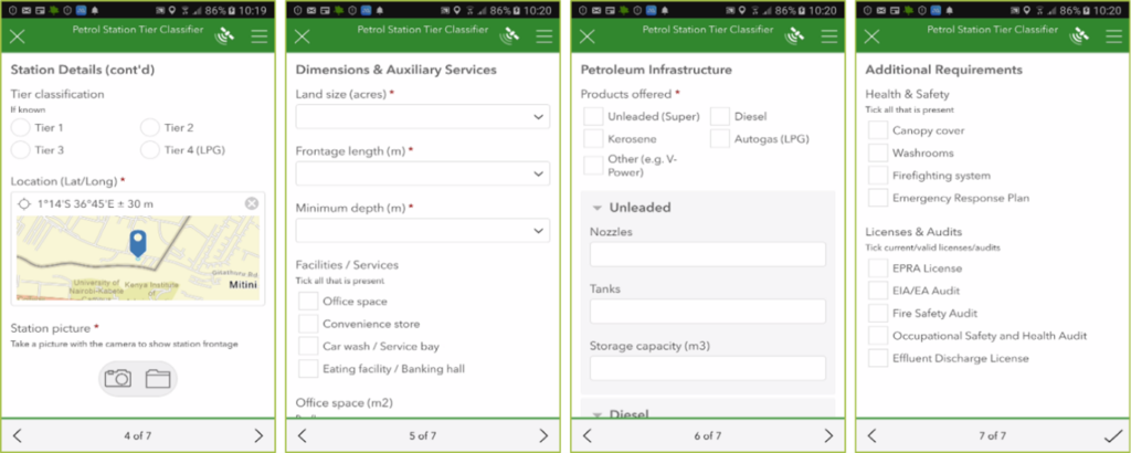
By using Survey123 field work was completed by the first week of November. Survey123 is a form-centric mobile data collection app that provided field enumerators with a fast, consistent, and easy to use tool. Survey123 runs on a basic smartphone which allowed enumerators to collect the location of the petrol retail stations and take a picture of their frontage. This information is vital to EPRA since it enables them to revisit the station for further data collection and inspections.
Field data collection started in Nairobi when travel outside Nairobi was restricted due to COVID-19. Data was collected by field teams consisting of a car with driver and a male and female field enumerator. The teams planned their daily routes by gleaning the location of petrol stations from commercial data sources. While driving they would stop at any other station.
At each station one enumerator interviewed the station manager while the other person would enter the data in a Survey123 form. In this manner a station could be surveyed in 20-30 minutes. Below is a sample from the multi-page form that was used.
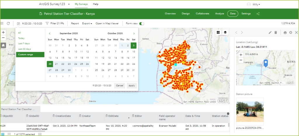
Survey123 even works in disconnected mode so enumerators could store survey data on their device and submit them when they obtain good Internet connectivity. Back in the office survey results would be viewed and analyzed in Survey123 web. This allowed managers to check on data accuracy, consistency, and completeness. Work progress was monitored, so that corrective action is taken if necessary. Some of this is shown in the screenshot below.
Results
The Survey123 form was designed in a matter of days, even though some improvements had to be made after the Nairobi pilot. Porting data from the old survey to the new one had a few challenges, but these were solved with the help of ArcGIS Pro.
Some of the field enumerators had no experience with GIS and ArcGIS but they got going with a 1-day training and soon became proficient in field data collection. The use of Survey123 was also very intuitive and greatly improved the planning of the field work.
Estimating land size and office space proved tricky even after the units were changed to acres. Mapping these as polygon features could have offered a solution, but time was a constraint.
An initial compliance assessment was performed after completing the field data collection. The results indicate that most petrol retail stations in Kenya are non-compliant with the requirements of KS2504:2014. The initial data need verification, but EPRA needs to act fast. The good news is that they have a GIS database that facilitates this.
EPRA received training on ArcGIS and technical documentation that enables them to maintain the GIS database and build web maps and apps in support of their operations. Below is a sample app that shows the distribution of tier 1, 2, and 3 station in Nairobi in its surroundings.
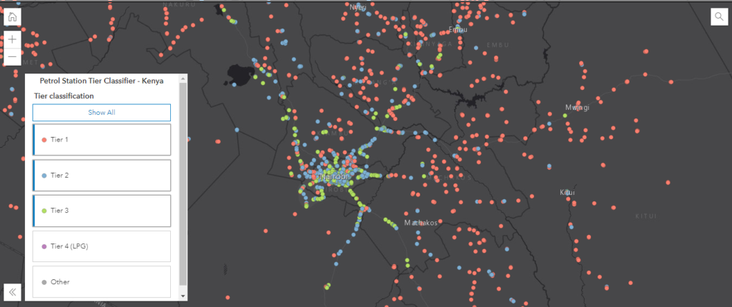
It shows that tier 2 and 3 stations are predominant in Nairobi County and that that tier 1 stations are predominant in other counties. We hope that you will soon be able to access this data and information via EPRA, the official source. Meanwhile, consider using ArcGIS Survey123 for your own field data collection in support of your business operations.
